


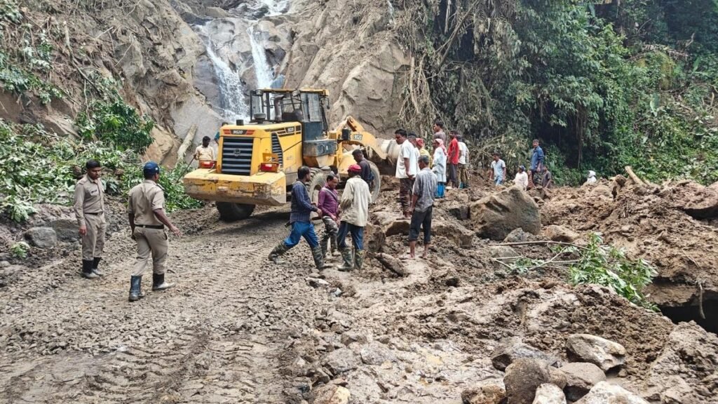
The Arunachal landslide dam emergency has prompted authorities to intensify monitoring after a massive landslide blocked the Siji River in Arunachal Pradesh’s Lower Siang district, creating a potentially hazardous artificial dam. Officials are assessing the stability of the natural barrier and downstream risks as water continues to accumulate behind the obstruction. Disaster management agencies, district authorities, and technical teams have been deployed to evaluate the situation and prepare contingency measures. Residents living near vulnerable riverbanks have been advised to remain alert while authorities closely monitor water levels and changing geological conditions.
Northeast Rainfall Deficit Despite Flash Floods
Arunachal Tribal Community Raises Concern Over Alleged Chinese Encroachment in Upper Subansiri
Massive Landslide Blocks Siji River
The Arunachal landslide dam emergency began after a large landslide deposited huge volumes of rock, soil, and debris into the Siji River in Lower Siang district, completely blocking the river’s natural flow. The obstruction created an artificial lake upstream as water rapidly accumulated behind the debris barrier. Officials immediately initiated field inspections to determine the size of the blockage, the volume of stored water, and the potential risk of a sudden breach.
Geologists and engineers are examining the stability of the natural dam because such formations can weaken without warning under increasing water pressure. The assessment includes monitoring water inflow, erosion around the blockage, and surrounding slope conditions. Authorities continue gathering real-time information to guide emergency planning and public safety measures.
The incident occurred during the active southwest monsoon season, when persistent rainfall increases the likelihood of landslides across the mountainous terrain of Arunachal Pradesh. The combination of saturated soil, steep slopes, and fast-flowing rivers has heightened the need for continuous surveillance.
Authorities Strengthen Monitoring and Preparedness
The Arunachal landslide dam emergency has led district authorities and disaster management agencies to strengthen surveillance around the affected river basin. Officials are using field observations and technical assessments to monitor changes in the artificial dam and identify any signs of structural instability.
Emergency teams have prepared contingency plans to respond quickly if water begins overflowing or if the natural barrier shows indications of failure. Local administrations are coordinating with state disaster response authorities to ensure that rescue equipment, communication systems, and evacuation resources remain ready if required.
Authorities have also advised residents in downstream areas to stay informed through official updates and avoid entering river channels or low-lying locations that could be affected by sudden changes in water flow. Public awareness remains a key part of reducing risks during evolving natural disasters.
Hydrological experts continue evaluating the volume of water accumulating behind the obstruction because increasing storage can significantly influence downstream flood potential if the barrier weakens unexpectedly.
Potential Risks for Downstream Communities
The Arunachal landslide dam emergency has raised concerns about the possibility of a sudden release of impounded water if the natural dam breaches. Such events can generate powerful flood waves capable of damaging infrastructure, agricultural land, bridges, and settlements located downstream.
Although no immediate breach has been reported, officials continue assessing river conditions to determine whether controlled intervention may become necessary. Technical experts are studying water pressure, seepage, and the structural composition of the debris to better understand the barrier’s stability.
Lower Siang district contains several communities that depend on river systems for transportation, agriculture, and daily activities. Consequently, authorities remain focused on protecting lives while minimizing disruption through timely warnings and coordinated response planning.
Environmental specialists also note that landslide-created dams can alter river ecosystems by affecting water flow, sediment movement, and aquatic habitats. Long-term restoration efforts may be required after the immediate hazard has passed.
Geological Challenges During the Monsoon
The Arunachal landslide dam emergency highlights the broader geological challenges faced by Himalayan states during the monsoon season. Heavy rainfall frequently destabilizes mountain slopes, increasing the likelihood of landslides that threaten transportation corridors, villages, and river systems.
Arunachal Pradesh’s rugged terrain makes continuous monitoring particularly important because intense rainfall can rapidly change landscape conditions. Government agencies regularly collaborate with geological experts and disaster management authorities to improve hazard assessments and strengthen early warning capabilities.
Advances in satellite monitoring, remote sensing, and field-based inspections are helping authorities detect potential risks more quickly. These tools support informed decision-making and allow emergency agencies to respond more effectively when natural hazards develop.
Officials have emphasized that continued monitoring of the Siji River will remain essential until the artificial dam no longer poses a threat to downstream communities or surrounding infrastructure.
Conclusion
The Arunachal landslide dam emergency underscores the serious risks posed by monsoon-induced landslides in mountainous regions. With a massive landslide blocking the Siji River and creating an artificial dam in Lower Siang district, authorities are maintaining continuous surveillance and preparing for any change in conditions. Ongoing technical assessments, coordinated disaster preparedness, and timely public advisories remain essential to protecting communities while reducing the potential impact of any sudden release of impounded water.
FAQs
1. What caused the artificial dam on the Siji River?
A massive landslide deposited rock and debris across the river, blocking its natural flow.
2. Where did the landslide occur?
The incident occurred in Lower Siang district of Arunachal Pradesh.
3. Why is the Arunachal landslide dam emergency significant?
The Arunachal landslide dam emergency is significant because a sudden breach could trigger downstream flooding and threaten nearby communities.
4. What are authorities doing to manage the situation?
They are monitoring water levels, assessing the barrier’s stability, and preparing emergency response plans.
5. Can heavy rainfall increase the risk further?
Yes. Continued rainfall can increase water pressure behind the natural dam and destabilize surrounding slopes.
6. What precautions should nearby residents take?
Residents should follow official advisories, avoid riverbanks, and remain prepared for emergency instructions.