


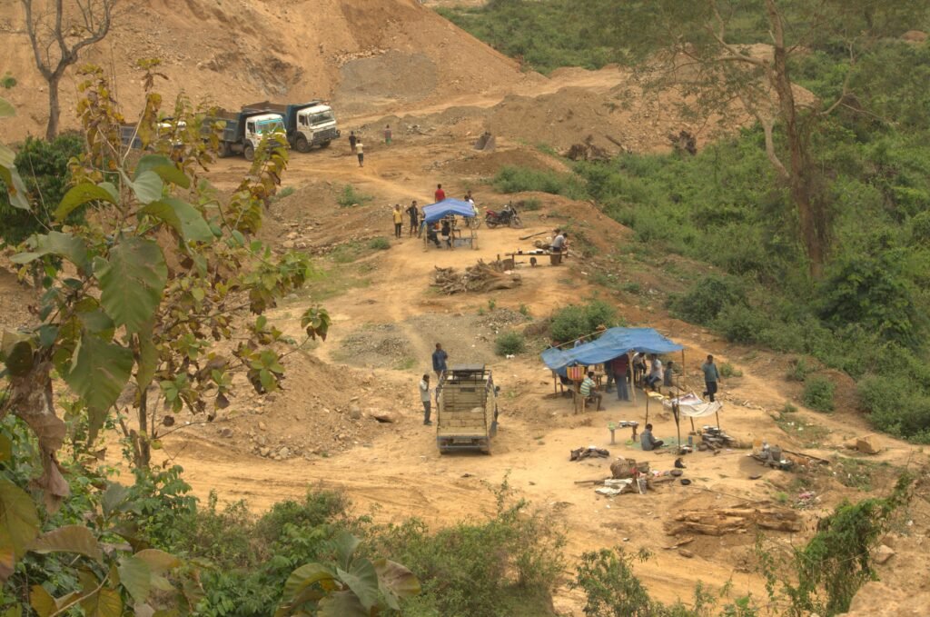
The Assam government faces renewed pressure to stop illegal stone mining near Kaziranga National Park and Tiger Reserve. The issue has returned to focus following fresh reports of quarrying around Parkup Pahar in Karbi Anglong. The area lies along Kaziranga’s southern boundary and forms part of an important wildlife landscape. The Supreme Court prohibited mining in this sensitive region in April 2019. Moreover, government records have documented closure orders against several stone quarries and crushing units. Recent concerns have raised questions about enforcement and the protection of wildlife corridors.
TTAADC Postpones Executive Members’ Oath Ceremony
Supreme Court Ban Covers Kaziranga’s Southern Boundary
The Supreme Court issued a significant direction on April 12, 2019, concerning mining near Kaziranga National Park. The order prohibited all forms of mining and related activities along the park’s southern boundary.
It also covered the catchment areas of rivers, streams and rivulets originating in the Karbi Anglong hills. These waterways flow towards Kaziranga and form part of its wider ecological system.
The court’s direction aimed to prevent mining-related damage in these sensitive landscapes. It also addressed concerns about the movement of illegally extracted minerals.
Furthermore, the order placed responsibility on Assam’s police authorities to prevent mining in the identified catchment areas. Police officials also received directions concerning the transportation of illegally mined materials.
The restrictions remain central to enforcement efforts around Kaziranga. Authorities must consider these directions when examining quarrying permissions and alleged violations.
Government Reports Closure Orders Against Quarries
The Union Environment Ministry provided an update on mining activities near Kaziranga in July 2025. The ministry reported that the Assam government had identified mining activities violating the Supreme Court’s directions.
As part of its enforcement response, authorities issued closure orders against 28 stone quarries. The orders also covered 18 stone crushers operating under the Northern Range, Dolamara.
These measures formed part of the state’s efforts to protect Kaziranga and its adjoining catchment areas. They also demonstrated the scale of quarrying activity that required administrative attention.
However, closure orders alone cannot guarantee permanent compliance. Authorities must monitor sites regularly and prevent suspended operations from restarting unlawfully.
The latest reports have again brought this enforcement challenge into focus.
Parkup Pahar Raises Fresh Environmental Concerns
A report published in November 2026 highlighted continued mining concerns around Parkup Pahar. The location lies along Kaziranga’s southern boundary in Karbi Anglong.
Environmental activist Rohit Choudhury reportedly approached the Union Environment Minister. He sought urgent intervention over alleged mining activities in the area.
The report also referred to concerns raised by the Central Empowered Committee. Its earlier findings indicated that some illegal mining operations appeared to have resumed despite previous restrictions.
These concerns involve more than the extraction of stone. Quarrying can affect natural drainage, hill slopes and surrounding vegetation.
Moreover, disturbed catchment areas can influence water flows towards the national park. Such changes may affect habitats used by wildlife.
The reported activity therefore requires careful investigation. Authorities must establish whether any operations violate existing court orders or applicable environmental restrictions.
Central Empowered Committee Seeks Stronger Enforcement
The Central Empowered Committee has repeatedly examined mining concerns around Kaziranga. Its recommendations have focused on enforcement, monitoring and scientific identification of sensitive catchment areas.
The committee called for police authorities to prevent illegal mining and the transportation of illegally extracted materials. It also stressed the need for coordinated action involving the Assam government and the Karbi Anglong Autonomous Council.
Another major recommendation concerned watershed mapping. The committee sought a detailed analysis of drainage areas flowing towards Kaziranga.
Such an assessment could help authorities identify streams, rivers and catchments that require protection. It could also support clearer decisions about mining restrictions and land-use permissions.
The committee further recommended that authorities avoid issuing fresh mining leases or permits in the relevant areas until the watershed boundaries receive scientific verification.
In addition, it sought regular status reports on enforcement measures. These reports would help track action taken against reported violations.
Wildlife Corridors Face Pressure From Quarrying
Kaziranga’s ecological importance extends beyond the national park boundary. The surrounding forests and hills support wildlife movement across the landscape.
The Karbi Anglong hills form an important part of this wider habitat network. Animals move between forest areas through natural routes and connected habitats.
Mining can disturb these connections through vegetation removal, excavation and increased human activity. Heavy vehicles and associated operations may also create additional pressure.
Elephants and other wildlife depend on suitable routes between feeding and shelter areas. Therefore, protecting surrounding landscapes remains important for conservation.
The issue also involves the rivers and streams that connect the hills with Kaziranga. Maintaining natural drainage systems supports the wider ecological balance.
Consequently, enforcement agencies must examine mining activity alongside its possible effects on wildlife habitats and water systems.
Administrative Coordination Remains Essential
The mining issue involves several authorities with different responsibilities. The Assam government, forest officials, police departments and the Karbi Anglong Autonomous Council all have roles in enforcement.
The forest department can monitor ecological damage and report violations. Police authorities can investigate illegal extraction and transportation.
Meanwhile, the autonomous council has responsibilities concerning local administration and mining-related permissions within its jurisdiction.
Effective coordination can help prevent gaps between enforcement orders and ground-level action. It can also improve information sharing between departments.
Authorities must verify mining permissions, inspect affected locations and investigate complaints. They should also ensure that suspended operations do not continue under different arrangements.
Regular field inspections and transparent reporting can strengthen accountability. Furthermore, scientific watershed mapping can help clarify which locations fall under restrictions.
Environmental Protection Requires Continued Monitoring
The latest concerns highlight the need for consistent monitoring around Kaziranga. Enforcement cannot depend only on occasional inspections or temporary closure orders.
Authorities must check whether previously closed quarries remain inactive. They must also investigate reports of fresh excavation and illegal mineral transportation.
Technology and field surveillance could support these efforts. However, monitoring systems must operate alongside legal action and local administrative coordination.
The government must also communicate verified enforcement outcomes. Clear updates can help distinguish confirmed violations from allegations that remain under investigation.
At the same time, conservation measures must follow applicable court directions and environmental regulations.
Protecting Kaziranga requires attention to the wider landscape. Its forests, hills, rivers and wildlife corridors form an interconnected ecological system.
Conclusion
Illegal stone mining concerns near Kaziranga have returned to public attention following fresh reports from Parkup Pahar. The Supreme Court’s 2019 order prohibits mining along the park’s southern boundary and in connected catchment areas.
The Assam government previously reported closure orders against 28 stone quarries and 18 stone crushers in Dolamara. However, recent allegations indicate that enforcement challenges may continue.
Authorities now face the task of verifying reported activity and ensuring compliance with existing restrictions. Continued inspections, police action and scientific watershed mapping remain important for protecting Kaziranga’s surrounding ecosystem.
FAQs
1. Why has illegal stone mining near Kaziranga become a concern?
Reports of continued quarrying around Parkup Pahar have renewed concerns about environmental damage and wildlife habitat protection.
2. When did the Supreme Court prohibit mining near Kaziranga?
The Supreme Court issued its mining-related directions on April 12, 2019.
3. Which areas fall under the mining restrictions?
The restrictions cover Kaziranga’s southern boundary and the catchment areas of rivers and streams originating in the Karbi Anglong hills and flowing towards the park.
4. How many quarries and crushers faced closure orders?
The Union Environment Ministry reported closure orders against 28 stone quarries and 18 stone crushers in the Northern Range, Dolamara.
5. What role does the Central Empowered Committee play?
The committee examines compliance concerns and recommends measures involving enforcement, watershed mapping and monitoring.
6. Why is protecting the Karbi Anglong catchment important?
The catchment areas support natural drainage and connect surrounding habitats with Kaziranga’s wider ecosystem.