


The Sub-Himalayan flood spillover has intensified flood concerns in lower Assam after extreme precipitation across the Sub-Himalayan regions of West Bengal caused rivers to swell beyond their normal capacity. Rising water levels have inundated several low-lying areas, disrupted transportation, and affected agricultural land in downstream districts. Authorities continue monitoring river conditions while disaster management agencies strengthen preparedness in vulnerable locations. Officials have also urged residents living near riverbanks to remain alert as additional rainfall could further increase flood risks during the active monsoon season.
Guwahati Urban Inundation Prompts Drainage Review
Nagpur University Students Discover Prehistoric Rock Art Heritage Site in Madhya Pradesh
Heavy Rainfall Raises River Levels
The Sub-Himalayan flood spillover began after persistent rainfall lashed the Sub-Himalayan belt along the West Bengal border. Consequently, rivers carrying runoff from the upper catchments transported large volumes of water into the plains of lower Assam. The sudden increase in river discharge raised water levels across several downstream locations.
Meanwhile, hydrological teams monitored river gauges and rainfall patterns throughout the affected basin. Engineers also reviewed inflow data to identify areas facing an elevated flood risk. Furthermore, authorities intensified surveillance at vulnerable embankments and drainage channels to detect any early signs of damage.
Although no major embankment breaches have been reported, officials continue monitoring the evolving situation because additional rainfall may worsen flood conditions.
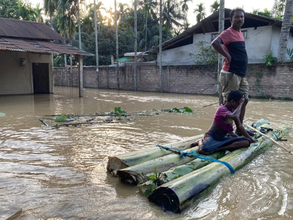
Floodwaters Affect Communities in Lower Assam
The Sub-Himalayan flood spillover has affected several low-lying areas across lower Assam, where overflowing rivers entered villages, farmland, and road networks. As a result, many residents experienced transportation disruptions and temporary restrictions on daily activities.
District administrations deployed emergency teams to monitor flood-prone communities and assist vulnerable residents. Meanwhile, disaster management authorities prepared relief materials and reviewed evacuation plans for locations facing a higher flood threat. In addition, local officials maintained regular communication with village leaders to ensure timely dissemination of official advisories.
Authorities also encouraged residents to avoid crossing flooded roads and remain away from swollen rivers until conditions improve.
Authorities Intensify Flood Preparedness
The Sub-Himalayan flood spillover has prompted state agencies to strengthen flood preparedness across affected districts. Emergency response teams continue inspecting embankments, drainage systems, and vulnerable riverbanks to reduce potential risks. At the same time, weather officials monitor forecasts to identify additional rainfall that could influence river conditions.
Furthermore, district administrations continue coordinating with flood control authorities to improve response planning and resource deployment. Officials have also instructed emergency teams to remain on standby for rescue and relief operations if water levels rise further.
Regular monitoring of upstream rainfall and downstream river discharge remains essential because changing weather conditions can rapidly alter the flood situation.
Monsoon Monitoring Continues
The Sub-Himalayan flood spillover highlights the interconnected nature of river systems across eastern and northeastern India. Heavy rainfall in upstream catchments can quickly influence downstream districts, even when local rainfall remains moderate. Therefore, authorities continue relying on real-time hydrological monitoring and weather forecasts to guide preparedness measures.
Moreover, experts recommend stronger interstate coordination, improved flood forecasting, and continuous river surveillance to reduce future flood risks. Officials believe these measures will improve emergency response and strengthen resilience during periods of intense monsoon activity.
Conclusion
The Sub-Himalayan flood spillover has demonstrated how extreme rainfall in upstream regions can rapidly affect downstream communities in lower Assam. Rising river levels have increased flood risks, disrupted normal activities, and prompted authorities to strengthen preparedness across vulnerable districts. Meanwhile, continuous monitoring, timely public advisories, and coordinated disaster response remain essential for protecting lives and minimizing the impact of further monsoon rainfall.
FAQs
1. What caused flooding in lower Assam?
Extreme rainfall across the Sub-Himalayan region of West Bengal increased river flows into downstream areas.
2. Which areas face the highest flood risk?
Low-lying villages and riverbank communities in lower Assam remain the most vulnerable.
3. What is the Sub-Himalayan flood spillover?
The Sub-Himalayan flood spillover refers to downstream flooding caused by heavy rainfall in the Sub-Himalayan catchments along the West Bengal border.
4. What measures are authorities taking?
Officials are monitoring rivers, inspecting embankments, preparing relief resources, and strengthening emergency response.
5. Why do upstream rains affect Assam?
Many rivers flow from upstream catchments into Assam, carrying excess runoff during periods of intense rainfall.
6. What precautions should residents follow?
Residents should monitor official advisories, avoid flooded areas, and follow evacuation instructions if authorities issue them.