
Meghalaya is adopting advanced technology to strengthen disaster preparedness as AI mapping landslide hotspots in Meghalaya reveals at-risk zones across the state. Officials said the initiative aims to help authorities identify vulnerable areas early, plan preventive measures, and protect lives and infrastructure in hilly regions prone to landslides. The integration of artificial intelligence with geospatial data marks a significant step forward in disaster management planning for the hill state.
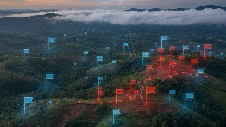
The AI mapping landslide hotspots in Meghalaya project uses satellite imagery, terrain data, rainfall patterns, and historical landslide records to pinpoint areas with high risk. This approach allows disaster management teams to monitor potential trouble spots more efficiently than traditional methods. Experts said the use of artificial intelligence helps process large volumes of data quickly and highlight patterns that may not be visible through manual analysis.
Read More: Tripura CM Takes Part in Bhumi Pujan for Airtel Data Centre
How AI mapping landslide hotspots in Meghalaya works
Officials explained that the AI system combines several layers of information to create detailed risk maps. These include slope gradients, soil types, vegetation cover, drainage patterns, and rainfall intensity. By analyzing these factors simultaneously, the technology can assign risk levels to different locations and update the information in real time as new data arrives.
The Meghalaya Remote Sensing and GIS Centre collaborated with technical partners to build the AI model. Developers said the system was trained on historical landslide events to improve its predictive accuracy. This means the AI can learn which terrain features and weather conditions are most likely to cause slope failures and flag similar patterns across the landscape.
Disaster managers will use the resulting maps to guide planning, evacuation routes, and early warning alerts. The visual representation of risk zones makes it easier for officials and community leaders to understand threats and take timely action.
Benefits for communities and disaster response
The AI mapping landslide hotspots in Meghalaya initiative offers several benefits for local communities. Risk maps help identify villages and road corridors that need monitoring during heavy rainfall. Officials said this information could trigger preemptive measures such as temporary road closures, reinforcement of vulnerable slopes, and community alerts.
Community volunteers said mapping helps them prepare safety plans and educate residents about potential hazards. When a location shows a rising risk level, local teams can activate early communication systems and support residents in high-risk areas. This proactive approach saves valuable time during extreme weather events.
Officials also noted that the technology can assist in long-term planning. When land use decisions are made for construction, agriculture, or tourism, risk maps will help planners avoid highly sensitive zones or implement mitigation measures such as retaining walls and drainage systems.
Strengthening Meghalaya’s disaster management framework
State authorities said AI mapping landslide hotspots in Meghalaya will become part of a broader disaster management strategy. With the monsoon season bringing intense rainfall each year, landslides remain a recurring threat in many parts of the state. Traditional monitoring methods often struggled to keep pace with rapidly changing weather and terrain conditions.
By integrating AI systems, disaster management departments expect faster detection and response capabilities. Officials also plan to share risk maps with district administrations, police, and emergency services so that all stakeholders have a common understanding of danger zones.
The state government emphasized that technology complements, but does not replace, on-ground monitoring teams. Local observations still play a key role in validating AI predictions and providing context that data alone cannot capture.
Challenges and future improvements
While AI mapping landslide hotspots in Meghalaya holds promise, experts acknowledge challenges remain. Data availability and quality, especially in remote areas, can affect the accuracy of risk prediction models. Maintaining up-to-date satellite imagery and weather inputs also requires investment and coordination with national agencies.
Technical teams said they plan to refine the AI model over time by incorporating feedback from field teams and updating training datasets. More ground sensors and automated weather stations could improve the precision of future maps.
Officials also highlighted the need for community education and training. When residents understand how risk maps work and why alerts are issued, they can participate more effectively in disaster response and preparedness.
Collaboration and regional impact
The success of AI mapping landslide hotspots in Meghalaya could serve as a model for neighbouring states facing similar terrain challenges. Experts said several northeastern states are exploring digital tools for disaster risk reduction, and this project may encourage broader adoption of AI solutions.
Regional coordination on data sharing, early warning systems, and response protocols can lead to more resilient communities across the hilly Northeast. By demonstrating the effectiveness of AI technology, Meghalaya positions itself as a leader in tech-driven disaster management innovation.
Long-term outlook for safety and planning
In the long term, AI mapping landslide hotspots in Meghalaya could shape how infrastructure, housing, agriculture, and tourism projects are planned. Risk-aware development strategies can reduce vulnerability, protect investments, and save lives.
Officials expressed confidence that the project will strengthen the state’s ability to face extreme weather events with preparedness and resilience. As technology evolves and data improves, AI systems will become even more capable of guiding safety measures that protect both people and property in landslide-prone regions.
By using advanced AI mapping tools, Meghalaya is taking a proactive stance against natural hazards and building a safer future for its communities. The initiative underscores how technology and local action can work together to reduce risk, improve planning, and enhance disaster readiness across the state.
Read More: BJP–TMP Tie-up Limited to Assembly Polls, No Alliance for TTAADC: Tripura CM