


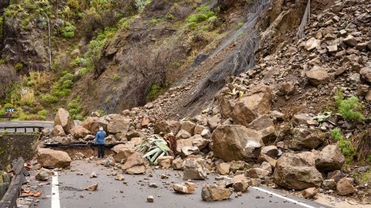
The Naga Tosa Road Blockage in North Sikkim has drawn attention after landslide debris along the newly cut Naga–Tosa Road in the Naga Forest area reportedly contributed to the temporary formation of a lake-like water body. The landslide struck Mangan district during the intervening night of September 5 and 6, 2026, affecting the surrounding terrain and nearby river system. Despite widespread property damage, the Mangan District Administration confirmed that no injuries or loss of life occurred in the incident.
Tripura University Debate Club Begins New Academic Chapter with Renewed Vision
Naga Tosa Road Blockage Follows Major Landslide
The Naga Tosa Road Blockage followed a substantial slope failure along the newly cut road section in the Naga Forest area. The landslide sent soil, rocks and debris across the surrounding terrain.
The debris disrupted the road and changed local drainage conditions. Meanwhile, the wider landslide affected the area above the Chyakoong River.
Reports identified a substantial hillside section along the newly cut Naga–Tosa Road near the Theng Tunnel as part of the affected area. The incident also partially disrupted the flow of the Teesta and Chyakoong rivers.
No Casualties Reported After Landslide
The incident did not result in reported casualties. The Mangan District Administration confirmed that the landslide caused widespread property damage.
However, no person lost their life or suffered injuries. This distinction remains important when assessing the overall impact of the event.
Moreover, the absence of casualties provides some relief despite the significant infrastructure disruption. Authorities still need to monitor the affected slopes closely.
Unstable ground can create further problems after an initial landslide. Therefore, continued observation remains important in the affected area.
Debris Creates Temporary Lake-Like Water Body
The formation of a temporary lake-like water body added another dimension to the Naga Tosa Road Blockage. Landslide debris can obstruct natural drainage channels.
Such blockages can temporarily change water movement across steep terrain. In this case, debris along the newly cut road reportedly contributed to water accumulation in the Naga Forest area.
The resulting formation appeared lake-like. However, authorities would need a detailed assessment to determine its exact size, depth and stability.
Teesta and Chyakoong River Flows Affected
The wider landslide also temporarily affected nearby river flows. Water accumulated in the Teesta and Chyakoong rivers after the landslide.
The Teesta later returned to normal flow. This development reduced immediate concerns over prolonged disruption to the river system.
Therefore, the temporary water body should not automatically be treated as a newly formed permanent lake. Instead, it appears linked to the temporary obstruction created by landslide debris.
Furthermore, the formation can change as water finds alternative drainage routes. Loose debris can also shift and alter the flow.
Property Damage Reported in Mangan
The Naga Tosa Road Blockage caused significant disruption to infrastructure in the affected area. The newly cut road section suffered from the movement of soil and debris.
The surrounding landscape also changed substantially after the slope failure. Despite the property damage, officials confirmed that no injuries or deaths occurred.
Meanwhile, authorities monitored the nearby river system because the landslide temporarily affected the Teesta and Chyakoong rivers.
Officials also issued precautionary alerts to vulnerable downstream areas while they assessed the situation. Monitoring therefore remained a key part of the response.
Teesta Flow Returns to Normal
The Teesta subsequently continued to flow normally. Monitoring posts reportedly recorded normal water levels.
However, officials continued to watch the area closely. Additional debris movement could still alter local drainage and river conditions.
Consequently, authorities must consider both road safety and water movement during the ongoing assessment.
Himalayan Terrain Creates Infrastructure Challenges
The incident highlights the vulnerability of infrastructure across Sikkim’s mountainous terrain. Roads provide vital connections for remote communities.
However, construction and maintenance in steep areas require careful attention to slopes and drainage. Geological conditions also play an important role.
The latest incident demonstrates how one landslide can create several secondary effects. Besides blocking roads, debris can damage property and obstruct waterways.
Technical Assessment Remains Important
Available reports do not establish that road construction itself caused the landslide. Therefore, any assessment of a direct connection should await a technical investigation.
A detailed assessment can help determine the condition of the slope and road section. It can also identify potential risks around nearby waterways.
Additionally, the absence of casualties highlights the importance of monitoring and local preparedness. Authorities can use these measures to respond quickly when ground conditions change.
Focus Remains on Safety and Monitoring
Attention now remains focused on clearing debris and assessing infrastructure damage. Authorities also need to monitor the stability of the affected slopes.
The nearby waterways require continued observation as well. Changes in debris position could affect drainage or river conditions.
The incident reinforces the need for disaster preparedness across vulnerable Himalayan districts. Early warnings, monitoring systems and rapid communication can support faster responses during landslides.
Conclusion
The Naga Tosa Road Blockage has created significant infrastructure and property concerns in North Sikkim. Landslide debris affected the newly cut Naga–Tosa Road and contributed to a temporary lake-like water body.
The wider event also disrupted nearby river flows. However, the Mangan District Administration confirmed that the landslide caused no injuries or loss of life.
The Teesta later returned to normal flow. Meanwhile, authorities continued monitoring the affected slopes, road section and waterways.
FAQs
1. What caused the Naga Tosa Road Blockage?
The blockage followed a major landslide in Mangan district during the intervening night of September 5 and 6, 2026, affecting the newly cut Naga–Tosa Road area.
2. Did the landslide create a permanent lake?
Reports describe a temporary lake-like water body created by debris and altered water movement. Further assessment would be required to determine its exact nature and duration.
3. Were there any casualties in the Mangan landslide?
No. The Mangan District Administration confirmed that despite widespread property damage, no injuries or loss of life occurred.
4. Which rivers were affected?
The landslide partially affected the Teesta and Chyakoong rivers near their confluence. The Teesta later returned to normal flow.
5. Why is the Naga Tosa Road Blockage significant?
It highlights the vulnerability of road infrastructure and drainage systems in Sikkim’s mountainous terrain, particularly when landslides affect newly developed road sections and nearby waterways.