


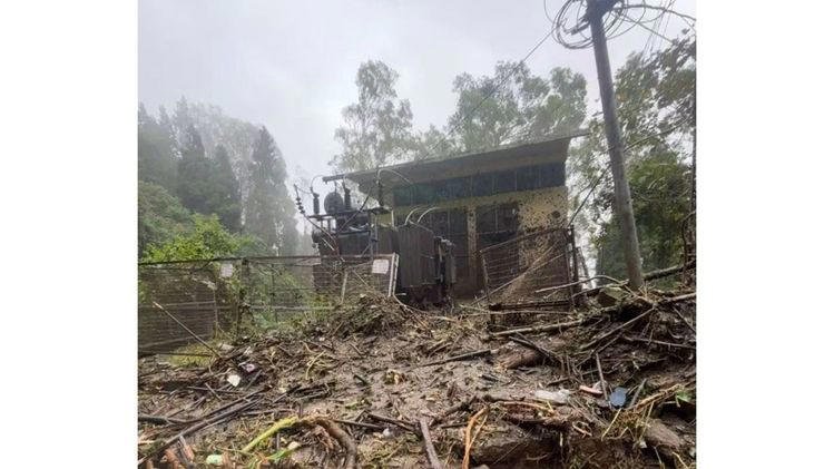
Heavy rainfall has triggered a series of landslides, mudflows and debris flows across Gangtok district in Sikkim. The incidents have blocked roads, damaged homes and affected public infrastructure in several parts of the district.
The District Disaster Management Authority (DDMA) has now launched a detailed damage assessment. Multi-agency teams are inspecting affected areas to identify the extent of the damage and determine where authorities need to take immediate action.
Officials began inspections on Wednesday and Thursday as heavy rain continued to affect the region. The teams are checking roads, residential buildings, public facilities and unstable slopes.
The latest assessment will help authorities prioritise road clearance, restoration work and assistance for affected residents.
Multi-Agency Teams Inspect Affected Areas
A multi-agency team led by Kabi Tingda MLA Tshering T Bhutia has inspected several rain-hit locations. DDMA officials, Roads and Bridges Department engineers, councillors, the Ranka Block Development Officer and revenue surveyors joined the inspections.
The teams are examining areas affected by landslides, mud and debris flows and road blockages. They are also checking residential structures that may face further risks because of unstable slopes.
The assessment covers a wide area across Gangtok district. Officials want to record damage accurately before authorities begin further restoration and relief measures.
The inspections also allow different departments to coordinate their response. Roads officials can identify blocked stretches, while revenue teams can assess damage to private property and public assets.
Several Localities Face Damage
The damage assessment covers numerous localities across Gangtok. These include Bojoghari, Lower Bojoghari, Lingding, High Court Road, TNA Gate, VIP Colony and Upper Z-Bojoghari.
Officials have also inspected the Pangthang-Lingdok Road, Pamro Gaon, Ling Perbing, Upper and Middle Luing, Phenzong and Ranka.
Other affected areas include Rakdong Tintek, Daragaon, Upper Burtuk, Sichey and Arithang. The wide geographical spread shows the impact of the recent rainfall across different parts of the district.
Several roads remain blocked by mud and debris. These obstructions have restricted vehicular movement and created difficulties for residents.
Authorities are continuing field inspections to determine which roads require immediate clearance and which areas need additional safety measures.
Homes and Public Infrastructure Also Affected
The rainfall-related incidents have affected residential structures in several locations. Some houses have suffered damage, while other buildings remain vulnerable because of continuing slope instability.
A landslide at Lingding in Tadong partially damaged a house during the early hours of Thursday. Mud and water entered rooms on the first floor. The incident also damaged three major water pipelines that supply the area.
The Lingding incident temporarily disrupted road connectivity. Local residents reported that the road near Lingding Jhora remained blocked for several hours before authorities restored access.
Public infrastructure has also suffered damage. The Sewage Treatment Plant at Sichey has been affected, while debris near the Enchey School 33/11 kV Switching Station has raised safety concerns.
Authorities Begin Road Clearance and Restoration
The Gangtok DDMA has directed concerned departments to clear roads and remove accumulated debris. Officials have also asked departments to restore connectivity and verify reports of damage.
The District Collector and DDMA chairman have instructed line departments to coordinate their work and provide assistance to affected residents.
Field teams will continue inspecting locations as authorities map the extent of the damage. The information collected during these assessments will help officials decide where to send resources first.
The administration has also placed tarpaulins over vulnerable slide zones. This measure aims to reduce rainwater seepage and limit further deterioration of unstable slopes.
Landslide Risks Remain a Major Concern
Sikkim’s mountainous terrain makes the state particularly vulnerable to landslides during periods of intense rainfall. Saturated soil and unstable slopes can increase the risk of sudden slope movement and debris flows.
Officials are therefore monitoring areas where residents have reported cracks, slope movement or falling debris.
The Gangtok administration has urged people to remain especially careful at night. It has also advised residents to avoid unnecessary travel through landslide-prone areas.
People living close to unstable slopes should watch for warning signs. These include new cracks in walls or roads, movement of soil and rocks, unusual sounds from slopes and falling debris. Authorities have asked residents to report such signs immediately.
Connectivity Faces Disruptions
Road connectivity remains one of the main challenges following the latest rainfall. Several roads across Gangtok district have experienced blockages because of landslides and debris.
The disruption can affect daily travel, emergency services and the movement of essential supplies. Authorities therefore consider road clearance an immediate priority.
The situation has also affected important road stretches around Bojoghari, Ranka and other areas. Teams from the Roads and Bridges Department are working with the disaster-management authorities to identify and clear affected sections.
The wider Sikkim region has also reported rainfall-related disruptions. Landslides have affected roads in other districts, while authorities have continued restoration and safety operations.
Sikkim Faces Wider Rain-Related Disruptions
The latest incidents in Gangtok come amid a broader period of heavy rainfall across Sikkim.
Gyalshing district has also faced landslide activity in areas such as Singlitam and Rimbi. The Sikkim State Disaster Management Authority has been monitoring those locations and coordinating relief and road-restoration efforts.
The situation highlights the continuing challenges that heavy rainfall creates for communities in Sikkim’s mountainous districts.
Authorities must manage both immediate emergencies and the longer-term risks linked to unstable slopes. Regular monitoring can help officials identify vulnerable areas before further incidents occur.
Officials Continue Ground-Level Assessment
The Gangtok DDMA will continue its inspections as officials assess the impact of the rainfall. Teams will verify damage reports and identify locations that need urgent intervention.
Road clearance, restoration of connectivity and support for affected households remain immediate priorities.
Officials also need to monitor vulnerable slopes because further rainfall could worsen existing damage. Residents near unstable areas have received warnings to remain alert and avoid unnecessary movement through dangerous zones.
The damage assessment will give authorities a clearer picture of the situation across Gangtok district.
Focus Shifts to Relief and Restoration
The latest rainfall has created challenges for residents, road users and public agencies across Gangtok. Landslides and debris flows have blocked roads, damaged houses and affected public infrastructure in several locations.
The ongoing DDMA assessment will help authorities determine the full extent of the damage. Departments will then focus on clearing roads, restoring essential services and supporting affected residents.
With heavy rain continuing to pose risks, authorities are also emphasising public safety. Residents in landslide-prone areas have been asked to remain vigilant and report signs of slope movement.
For now, Sikkim’s priority remains damage assessment, road restoration and preventing further harm as teams continue to monitor the rain-affected areas of Gangtok.