


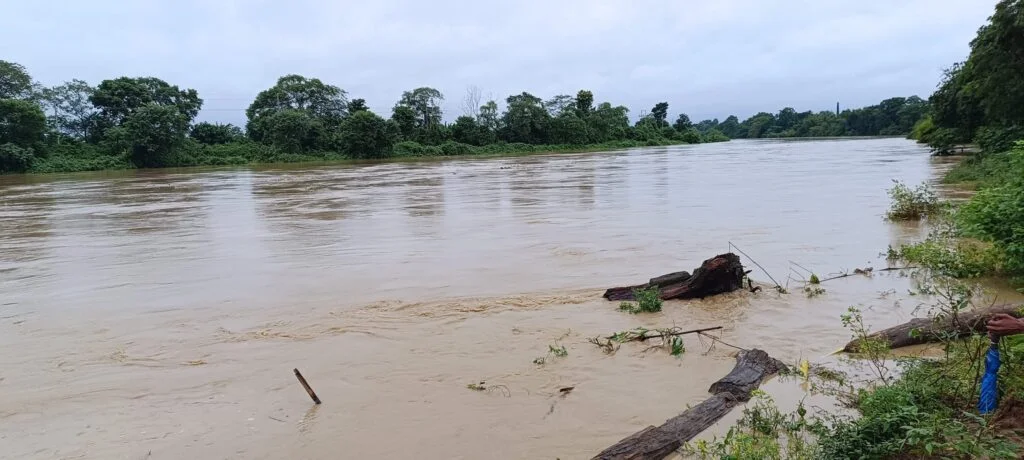
Unregulated soil excavation has raised fresh concerns about Khowai River bank erosion in parts of Tripura, where vulnerable stretches already require repeated protection work. The concern comes as authorities continue to undertake anti-erosion projects along different sections of the river. Recent government-linked tender records show multiple works involving bank protection, revetment and flood-damage repairs in Khowai district.
The Khowai River passes through areas where riverbanks support homes, farmland, roads and other local infrastructure. Consequently, changes to the riverbed or removal of soil near vulnerable stretches can increase pressure on already unstable banks. However, individual cases of excavation should be assessed by the competent authorities before officials attribute specific erosion events to a particular activity.
Sikkim Special Gram Sabha Drives Awareness of Watershed Schemes and SHG Livelihoods
Khowai River Bank Erosion Remains a Persistent Concern
The issue of Khowai River bank erosion is not new. Earlier environmental assessments identified erosion along the Khowai and other Tripura rivers, particularly in floodplain areas where riverbanks can remain vulnerable to lateral cutting and collapse. A Tripura State of Environment report noted that younger alluvial soils occur along the flood plains of rivers including the Khowai and warned that bank collapse required attention.
The river’s floodplain characteristics make erosion a significant seasonal concern. During periods of high flow, water can exert greater pressure on exposed banks. Therefore, any disturbance that removes stabilising soil or changes the river’s flow pattern can potentially worsen local instability.
Historical assessments have also linked uncontrolled riverbed mining with bank erosion in several Tripura rivers, including the Khowai. An East and Northeast India review reported concerns about machine-based lifting of riverbed material and its possible relationship with collapsing riverbanks.
Such historical evidence does not automatically establish that every present-day erosion incident results from excavation. Nevertheless, it demonstrates why authorities need to monitor extraction activities closely, especially near vulnerable river sections.
The concern becomes more important where agricultural land, homes or public infrastructure lie close to the river. Once a bank begins retreating, repeated high flows can gradually remove additional material and increase the affected area.
Anti-Erosion Projects Highlight Vulnerable Stretches
The scale of ongoing protection work provides another indication that Khowai River bank erosion remains an important infrastructure concern. In 2026, a ₹3.6 crore project was awarded for 400 metres of anti-erosion work near Kalibari and the Darikapur Anganwadi Centre under Kalyanpur RD Block in Khowai district. The project involves protection with cement-concrete blocks.
Another 2026 project covers anti-erosion work near Baishgharia Bridge under Dakshin Krishnapur Gram Panchayat in the Teliamura area. The project involves approximately 150 metres of bank revetment using cement-concrete blocks.
Meanwhile, authorities have also moved on flood-damage repair and anti-erosion works under the Khowai Sub-Division for 2026-27. Recent tender records identify work involving PVC wire crates, bamboo palisading and gunny-bag placement at different stretches under Khowai Block and the Khowai Municipal Council area.
A separate tender covers similar flood-damage repair and anti-erosion measures under Tulashikhar Block. These works indicate that officials are using different forms of bank protection according to local conditions.
These projects do not by themselves prove that excavation caused the erosion. Instead, they show that several stretches already require engineering intervention. This makes prevention and regulation important alongside post-damage repair.
Excavation Can Alter Riverbank Stability
The relationship between excavation and Khowai River bank erosion requires careful scientific assessment. Removing soil or sediment can change the shape and depth of a riverbed. In some circumstances, that change can influence water velocity, sediment movement and the pressure exerted on nearby banks.
Environmental observations from another Khowai River system have illustrated how uncontrolled excavation can create deep depressions in a riverbed. Water movement around such depressions may produce stronger local currents and contribute to further bank erosion, particularly during the rainy season.
That evidence comes from the Khowai River in Bangladesh and therefore should not be treated as direct evidence about every location in Tripura. However, the underlying river-management concern is relevant: excavation within or close to a river can alter natural sediment and flow conditions.
Tripura’s own environmental records have previously raised concerns about riverbed material extraction and erosion. The state’s river systems include fertile alluvial floodplains, but these areas remain susceptible to lateral erosion and bank collapse.
For that reason, regulated extraction requires clear boundaries, environmental safeguards and monitoring. Authorities also need to distinguish authorised river-management work from unapproved soil removal before taking enforcement action.
Furthermore, excavation should not occur in a manner that undermines existing embankments, protection structures or naturally stable sections of the riverbank. Careful site assessment can help reduce the possibility of shifting an erosion problem from one location to another.
Regulation and River Protection Need Stronger Coordination
Preventing further Khowai River bank erosion will require coordination between water-resource authorities, district administration and agencies responsible for regulating extraction. The Khowai district administration maintains a District Disaster Management Plan for 2026-27, reflecting the need for preparedness against local hazards and emergencies.
Regular inspections can help authorities identify fresh excavation, damaged banks and changes in vulnerable river stretches. Officials can then compare field observations with approved project boundaries and determine whether activities comply with applicable rules.
The district also maintains a Draft District Survey Report on Sand Mining among its official documents. Such survey and regulatory records provide an administrative basis for understanding extraction locations and managing river resources.
At the same time, erosion protection cannot depend entirely on concrete structures. Revetments, wire crates and other engineering measures can protect selected stretches, but river systems also need appropriate sediment management and protection of naturally stable banks.
Local residents can also play an important role by reporting visible changes along vulnerable stretches to the appropriate authorities. Early information can help officials inspect a site before erosion reaches houses, farmland or public infrastructure.
Ultimately, the priority should be a balance between legitimate development needs and river protection. Stronger monitoring of excavation, transparent regulation and timely anti-erosion work can reduce risks while allowing authorities to respond to unavoidable seasonal changes.
Conclusion
The growing concern over Khowai River bank erosion comes against a backdrop of repeated anti-erosion projects across vulnerable sections of the river. Recent works in Khowai and Teliamura show that authorities are already investing in bank protection and flood-damage repairs.
However, engineering repairs alone cannot address every cause of riverbank instability. Regulating soil and sediment excavation, monitoring river morphology and protecting vulnerable floodplain areas remain equally important.
A coordinated approach can help protect farmland, settlements and infrastructure while maintaining the natural functioning of the Khowai River. Any allegation of unregulated excavation should also undergo proper field verification before authorities establish responsibility.
FAQs
What is causing concern about Khowai River bank erosion?
Khowai River bank erosion remains a concern because several stretches require protection works, while changes to riverbeds, high flows and human activities can influence local bank stability.
Can soil excavation increase riverbank erosion?
Excavation can potentially alter riverbed depth, sediment movement and water flow. However, authorities need site-specific assessments before determining whether a particular excavation activity caused or accelerated erosion.
Are anti-erosion works underway in Khowai district?
Yes. Recent projects include cement-concrete bank protection and revetment works in areas such as Kalyanpur and Teliamura, along with flood-damage repair measures under the Khowai Sub-Division.
Why is the Khowai River vulnerable to erosion?
Parts of the Khowai floodplain contain alluvial soils that can experience lateral river cutting and bank collapse during changing flow conditions. Historical environmental assessments have identified this vulnerability.
How can Khowai River bank erosion be reduced?
Khowai River bank erosion can be addressed through regulated excavation, regular inspections, appropriate bank-protection structures, flood preparedness and protection of naturally stable river sections.